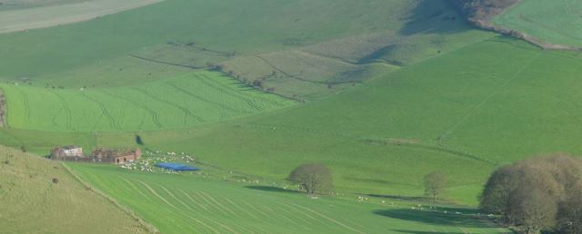
Illustration 1: General view of Balsdean from The Bostle (MRF-DSC_0065 extract November 2017)
Balsdean Farm stands on the top of High Hill overlooking Rottingdean. East of it, at the foot of the hill, is Balsdean pumping station. Woodingdean boasts a Balsdean Road, and a plaque in Balsdean Bottom records the site of the altar of the Norman church of Balsdean. Close by is a group of ruined farm outbuildings alongside a metal barn still in use. These are the only obvious remains today of the name of the once thriving settlement of Balsdean. Where was it, what happened to it, and what else can be seen of it are questions frequently asked by many people who enjoy an occasional walk on the Downs.
The original 1970 edition of this book was the result of an attempt over a number of years to answer these questions, and to explore and understand the long and varied history of this Downland settlement. While there are still a small number of copies of that edition about, my research has continued unabated, leading to more comprehensive second and third editions in 1978 and 1986. In the intervening 48 years I've also carried out parallel and much more detailed studies of the development of Woodingdean, Westbourne and Whiteparish both on the ground and from archive material. Progressively since the early 1990s the internet has provided ever easier access to a rapidly expanding local history resource, making it much easier to review and cross-check information and sources. This edition takes the opportunity to add a lot more detail and photographs and bring the story up to date, but of course the research goes on and I already have several more chapters in preparation.
Illustration 1: General view of Balsdean from The Bostle (MRF-DSC_0065 extract November 2017)
Balsdean lies in a valley bottom a couple of miles north of Rottingdean and was almost certainly originally settled from Rottingdean. Nowadays it is more easily located from Woodingdean, as it is only a mile east of the Downs Hotel crossroads. Until about 1970 a track ran directly to Balsdean across the Downs from here, and the part of this road lying in Woodingdean still bears the name Balsdean Road. When I moved to Woodingdean in 1959 and until about 1965 the signpost at the Downs Hotel crossroads had an arm marked "Balsdean" pointing east along Warren Way.
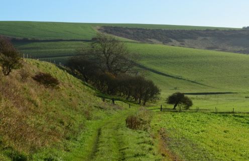
Illustration 2: Approaching Norton and Balsdean down Falmer Bottom, looking southeast MRF-DSC_0633 November 2017
To the casual observer little remains to be seen of Balsdean, and being above the level of the track, even the memorial plaque marking the position of the church can easily be passed unnoticed. Closer examination of the site, however, reveals that the area is covered with small banks, mounds and hollows, and that there are overgrown piles of bricks, flints and masonry here and there. Large concrete areas can still be seen, the remains of more recent buildings, and for the more experienced the outlines of older buildings and of the flint walls which once stood round Balsdean can be traced.
The site of Balsdean is about two miles from the coast at the point where three valleys, known as Balsdean Bottom, Falmer Bottom and Standean Bottom, meet at the head of a valley leading to the cliffs at Saltdean (see map below). The relatively level area in the valley bottom is about 200 feet above sea level, much the same height as most of the old settlements that existed on the block of Downland between the River Ouse and the centre of Brighton. The main part of Balsdean was quite compact, lying north of the steep sunken track from Woodingdean, and south of the group of currently ruined farm buildings. Just out of sight in the valley to the north-west of these buildings in Falmer Bottom stood a small outlying farm called Norton. Here again there is clear evidence on the surface of buildings, walls and disturbed ground as well as a quarry dug into the enormous field lynchet to the north.
Figure 1 Balsdean and adjacent settlements
The name Balsdean is of Saxon origin, and one possible derivation proposed is that it meant Beald's valley (ref **). No documentary records of the village have been found from before about 1091, although many remains found in the area show that people were around very much earlier. In earlier times people had lived on the summits of the hills, where the lighter soils were better suited to the early forms of plough. The large hill to the south of Balsdean, called the Bostle, displays many examples of Bronze age burial mounds, or tumuli, and some Bronze age remains have been found in the village area itself. In this area during Roman times, Romano-British people lived on the downs and the more affluent settled on the coastal plain from Brighton westwards and in the lower valleys, so few Roman remains have been found on the block of Downland around Balsdean. The earthwork on Castle Hill was considered to be a Roman fort or settlement in the past, but given the general settlement pattern seems rather unlikely, although there have been finds of Roman coins and burial urns around Balsdean. There was a Romano-British settlement two miles away on Highdole Hill, near Telscombe, and the Roman remains found at Balsdean may well have been associated with this.
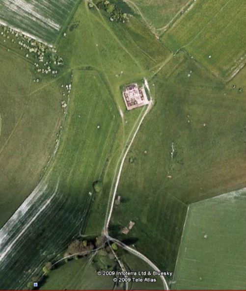
Illustration 3: Balsdean from above in 2009
Google Earth: copyright 2009 Infoterra Ltd & Bluesky; 2009 Tele Atlas
Saxon invaders settled Sussex rapidly between 477 and 490 (Anglo-Saxon Chronicles), pushing the Romano-British people into the Weald as they moved eastwards along the coast. Their early settlements were along the coast and up the major river estuaries and rivers, the estuaries being much deeper and wider at that time. Settlements spread next along the spring line on the north side of the South Downs, and Balsdean was almost certainly a slightly later area to be settled. The level area here is clearly a perfect settlement site, with the flat valley bottoms presenting ideal conditions for farming, and the hills around giving a measure of shelter from the weather. It may also have been convenient not to have been too visible from the coast in case of raiders, even though it seems clear from early settlement patterns that easy access to open water was an important feature in choosing a site.
((**Map of Sussex rivers**))
There is a range of theories on the settlement of Sussex by the Saxons, based on on the evidence presented by the Anglo Saxon Chronicles, on place name study and on archaeology. These theories continue to receive detailed academic attention, and have been challenged in many ways by carefully constructed arguments based on archaeology and further consideration of place names (ref **). Caution is required when interpreting archaeological evidence, as coverage is inevitably patchy, and scenarios based on current archaeology are often rewritten completely in later years when further evidence comes to light.
With these caveats, the general story set out by the Anglo-Saxon Chronicles still gives a believable picture of the Saxon invasion of Sussex. From Aelle's landing in A.D. 477 in the Selsey area, Sussex was quickly taken over the following twenty three years, so that when in 490 Aelle besieged and took Anderitum (Pevensey Castle) the Britons had been completely driven out to the north. The first phase of Saxon settlement was concentrated along the coast and in the then deep and wide tidal estuaries of the Arun, Adur, Ouse and Cuckmere, now long since silted up. At the time sea going shipping, much smaller of course than that of today, would have been able to come and go as far inland as Bramber and Lewes at any state of the tide. Indeed, as late as 1377 Lewes received an unwelcome visit from French raiders, who anchored close by the town and caused considerable distress to the local people. They also came to Rottingdean and were fought in the vicinity of Balsdean, but more of that later.
Early Saxon settlement sites also include those along the north scarp of the Downs, where the excellent water supply of the spring line and the agricultural potential of the light sandy soils at the foot of the Downs led the settlers away from the estuaries. Later, as the population grew, villages were established further into the Downs and onto the Weald. In the latter case there is evidence that the Saxons went deep into the Wealden forests to fatten pigs on the acorns and beech mast quite early in the settlement phase. An example is a document relating to Stanmer dated 877, which mentions the swine pastures at places as far away as Walstead and Lindfield on the forest ridge. It was only later that farming became feasible on the heavy clay soils of the Weald, and summer huts gradually became permanent settlements, with fields carved out of the woodland around them. Balsdean appears to fit in towards the end of this succession of settlement phases, when expansion was taking place onto the Downs, although the name Balsdean itself does not fall easily into a group of readily dated place names. While the common place name element Dean has spread widely in the Brighton area through the centuries, there is plenty of documentary evidence that Balsdean itself was an early and original Saxon naming.
Wilfrid, exiled bishop of York, came to Sussex in 681, staying for some 5 years, and is credited with establishing and spreading Christianity to the kingdom, although of course Christianity had been here before during later Roman times and until the Saxons arrived in 477.
There is no mention of Balsdean in the Domesday book, which was a tax survey of the entire country carried out at William the Conqueror's command soon after the Norman invasion. The omission can't be taken to mean that Balsdean did not exist, two common explanations for omission of known settlements being tax evasion and the inclusion of a small settlement in the return of a nearby larger one. Balsdean would probably have been included as part of Rottingdean.
.jpg)
Illustration 4: Rottingdean parish in 1951 (from maps.familysearch.org)
[add border of modern parish]
The Hundred of Younsmere included or included parts of Falmer, Ovingdean, Rottingdean, Balmer and Stanmer at various dates. Within it the old parish of Rottingdean (see above) was in two separate portions, the southern one containing Rottingdean, and extending along the coast to Black Rock, while the northern one contained Balsdean, described in the Victoria County History of Sussex Volume 7 as the ancient chapelry of Balsdean. The two sections of the parish only met at one point, and this gives rise to the idea that Rottingdean and Balsdean might originally have been separate and independent settlements. Even if this was the case, however, Balsdean was annexed to Rottingdean at an early date, and certainly before 1175.
The siting of an early village so high in what is now a dry valley seems rather odd at first sight. Few early settlements are far from an obvious source of water, which would have been a very important factor in the choice of a site. Even now, and despite the heavy water extraction from lower geological layers at the nearby Balsdean pumping station, the water level in the wells at Balsdean is often not many feet below ground level, so it is worth considering factors that may have led to a fall in the water table since the foundation of the village. Clearly, if water had been present originally as a stream or spring, it would have been a simple exercise to follow a falling water level by sinking shallow wells. The first point to note is that the Downland valleys are by no means devoid of water. Streams in the Brighton area have been covered up, but a visit to the beach below Pool Valley in Brighton at low tide quickly reveals that the old Wellesbourne river through the valley gardens is still as active as ever, even though it is piped now all the way from its source at Patcham to the groyne by the Palace Pier. Streams on the south slope of the Downs are much more in evidence further west in Sussex, and many more exist through winter and spring only, still known as bournes and lavants in country districts. Stream flow is occasionally resumed during very wet winters at the head of the Bevendean valley nearby, a point even higher above sea level than Balsdean.
Three obvious suggestions can be forwarded for the drop in the water table at Balsdean. It is generally accepted that rainfall is lower now that in the Saxon period (reference *), and local cliff erosion is likely to have been another contributing factor. It is believed that at least a mile of coastal erosion has taken place since the Norman conquest (reference *), when there would have been a very different coastline, probably with a flooded estuary south of Rottingdean. As the cliffs receded, the water table would have progressively fallen at Rottingdean towards sea level, with a smaller but nevertheless significant effect further inland. The third factor is that ever larger amounts of water have been extracted to cope with the growing population of Brighton, especially during the twentieth century, and this has had an impact on water levels throughout the chalk of the Downs.
As water must have been associated with the beginnings of Balsdean, water was also in at the end. In 1926 the Brighton Water Department's water supply from the Balsdean pumping station, a mile down the valley from Balsdean, was already of sufficient importance that the valley was bought by Brighton Council to safeguard the supply. In 1972 this well was the largest of the Authority's sources of water, with pumps capable of extracting up to 4.5 million gallons a day, although Brighton Water was keen to stress at the time that this full capacity was only reached occasionally (personal communication from Southern Water dated 26th September 1978). During the second World war many remote areas of downland and their hamlets and farms were requisitioned for army training, including Balsdean, and the buildings of Balsdean were used for target practice. Replacement farm buildings were built a mile to the south at what is still Balsdean Farm (2018), and although new outbuildings were erected at Balsdean after the war was over, houses were not included, either because of the importance of the local water supply or for the simple convenience the new buildings offered in terms of easy access to Rottingdean.
The move to the new site drew to a close a period of something over 900 years during which men, women and children had lived and worked at Balsdean. The following chapters explore in more detail the story of this settlement and farm, and the people who called it home.
Previous section Welcome to Balsdean
Next section Chapter 1 continued: Younsmere Hundred
Next chapter Chapter 2 Recorded History
Previous Section of this chapter Top of Chapter 1, Introduction
Copyright 1970-2018 Last updated 4.12.2018